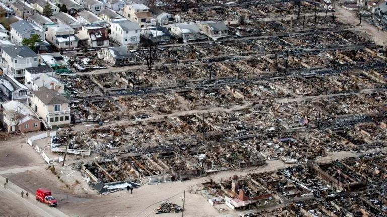
Scientists warn that the damage wreaked by Hurricane Sandy is a glimpse of what is to come with future storms as climate change fuels rising seas and more powerful extreme weather events. NRDC's analysis of the damage, in human terms, finds New York City not yet prepared for this future. NRDC's mapping analysis estimates that nearly 290,000 New Yorkers in the five boroughs of New York City were unexpectedly flooded by Sandy's stormwaters. The Federal Emergency Management Agency (FEMA) flood zone maps in effect when Sandy struck were nearly 30 years out of date, leaving hundreds of thousands of people less prepared for Sandy's flooding than they might have been.
What did Sandy do in the New York City region?
Flooding covered 46.2 square miles, an area 65 percent larger than the flood-vulnerable area identified by FEMA's outdated maps; the agency's "100-year flood zone" left out an estimated 21.4 square miles of the flooded city. This unexpectedly flooded area is home to tens of thousands of people highly vulnerable to flooding's harmful health effects; these include more than 16,000 children under 5 years old and 43,000 people 65 years and older, who must rely on others to help them get safely out of harm's way in emergencies; and nearly 90,000 people whose economic means to recover are especially limited. More than 121,000 New Yorkers lived in public housing developments that were flooded or lay within the flood risk zones. Fifty-two such buildings were impacted by flooding, and over 61,000 people in 28 of those NYCHA buildings, were outside FEMA's 100-year flood risk area.
What did we learn about public health preparedness from Hurricane Sandy?
The record-breaking flood height and storm surge that accompanied Sandy was on par with the 2009 New York City Panel on Climate Change projections for the 2050s. NRDC's mapping analysis gives a clearer picture of the human cost of FEMA's underestimation of flooding risks, and taught valuable lessons for the future:
- Coastal cities are increasingly flood-vulnerable because of climate change.
- Current flood preparedness policies are not adequate, in part due to FEMA's outdated process for flood risk mapping.
- Especially in densely-populated cities, the impacts of coastal flooding can be huge.
- Vulnerable populations are especially in need of heightened flood preparedness.
- For cities to be more climate-resilient, greater preparedness is urgently needed.
Recommendations to enhance climate-health preparedness and coastal flood resilience
Projections suggest that the extent of flooding New York City experienced with Sandy could become a regular occurrence (every two years) by 2100 if rapid sea level rise occurs. New York City is not alone, and the impact of Sandy highlights the vulnerability of coastal cities nationwide. To improve coastal resiliency, FEMA has an important opportunity to include the effects of climate change in its future flood-zone mapping efforts, in New York City and across the nation. Without this action by FEMA, large numbers of storm-vulnerable communities will be less than fully prepared for climate change's effects and are likely to find themselves in harm's way. And a growing number of sources, at the local, state, and federal levels, can help planners estimate how climate change will affect the extent of storm-related flooding. At the same time that communities take steps that include making buildings more climate-resilient, and establishing flood preparedness plans in advance among storm-vulnerable residents, to help reduce the worst future effects for coastal communities, action is also needed to limit heat-trapping carbon pollution that is fueling climate change and the sea level rise that heightens storm surge.
Paying attention to climate change and how it affects flooding has a payoff: The costs of flood preparedness measures are outweighed by the benefits of reduced flood damage by a factor of five to one. The best available science must be applied to help protect coastal residents' health and welfare nationwide.


